Sunday, November 23, 2014

Parc des Buttes-Chaumont

The late November weather in Paris is predictably rainy and gloomy.  A rare sunny day is a terrible thing to waste. With that in mind, Erica, Eric and I ventured out to the 19th arrondissement to visit the Parc des Buttes-Chaumont for une randonnée (hike).  

Parc des Buttes-Chaumont is named for the bare hill (chauve-mont) on which it was built.  Due to the chemical composition of the soil, the site was almost completely devoid of vegetation and the neighborhood had a sinister reputation.

photo Henri Le Secq, 1852

All of this changed when Baron Haussmann chose the site for a new pubic park in 1864.  With great effort, work was completed in three short years, a remarkable accomplishment. The park opened to acclaim in 1867 for the Paris Universal Exhibition. It has been a popular destination for Parisians ever since. It is most remarkable that this beautiful park, this nature reserve in the city, is a man made creation.


Parc des Buttes-Chaumont centers around an artificial lake, which surrounds a rocky island (Île de la Belvédère). The steep cliffs are formed out of an old gypsum quarry.


At the top of the mount is the Temple de la Sibylle, a smaller re-creation of the ancient Roman Temple of Vesta in Tivoli.

The island is connected by two bridges with the rest of the park.  We crossed the 63-meter-long suspension bridge designed by none other that Gustave Eiffel.


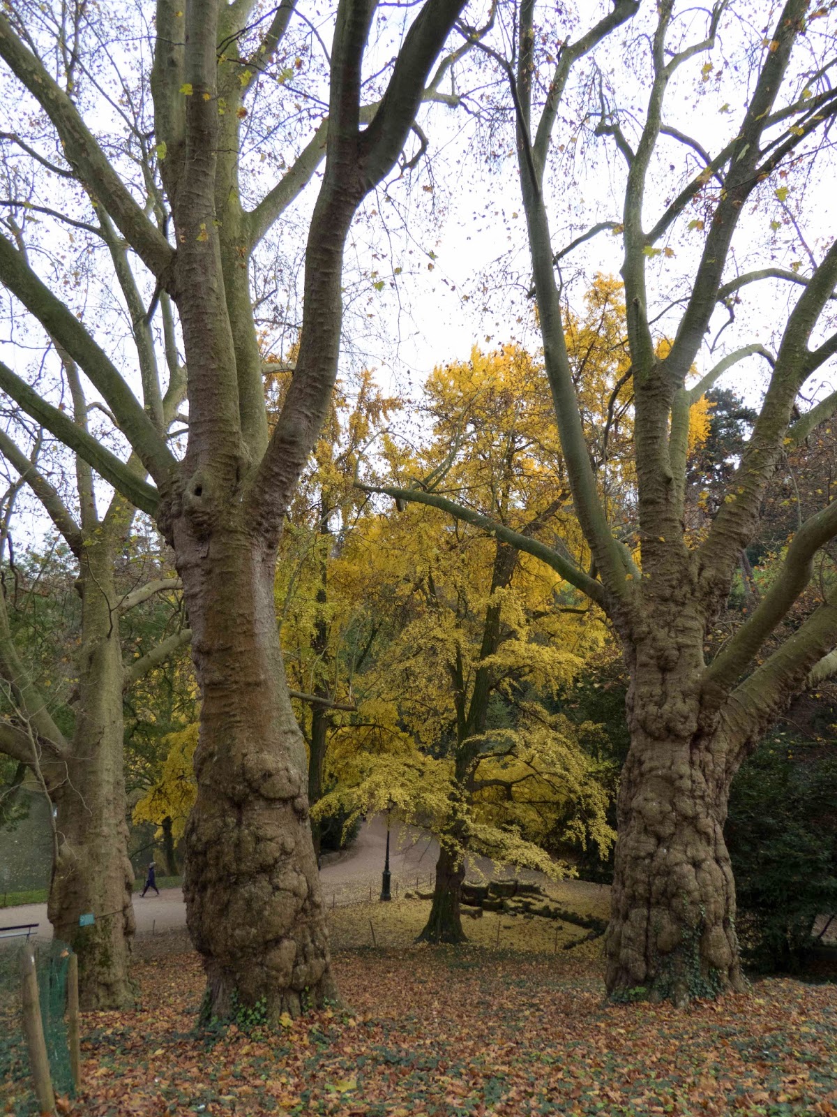
On the day we chose to visit the park, the fall foliage was at its peak and honey-colored afternoon sunlight filtered through the clouds. The temperature was brisk but not cold. Tourists were mostly absent. Amongst the many strollers we saw couples in love, families with young children, and contented older couples out for a walk.


After two hours, we returned home with our spirits renewed.   

Wednesday, November 19, 2014

The Bayeux Tapestry

This is actually an extension of the Normandy entries.  On our 3rd day in Normandy, we visited the city of Bayeux and the Tapestry depicting the events leading up to the Norman Conquest of England, the Battle of Hastings in 1066. The "Tapestry" which is actually embroidery, was made in the 1070's. It measures 70 meters (230 feet) in length, 50 cm (20 inches) wide. It's survival nearly intact is considered "little short of miraculous". Wikipedia has an excellent entry which can be found here.

The tapestry tells the story in pictures of scenes occurring from 1064 to 1066 of William, Duke of Normandy (William the Conqueror). It represents early "narrative art" intended for an audience that was mostly illiterate depicting the invasion. Bryan Talbot referred to the tapestry as "the first known British comic strip". There have been many knock-offs, including this New Yorker cover by Rea Irvin in 1944.

July 15, 1944
These are pictures I took of the tapestry. They do not begin to capture the story.


By clicking here, you are taken to a .jpg file in the Wikipedia web site that shows in detail the entire length of the tapestry. Try it!

Down the street from the museum housing the tapestry sits the Cathedral of Notre-Dame in Bayeux. The tapestry resided here for many centuries prior to finding its way to its new home in the museum built to house it.


There is one particular scene fairly early in the tapestry sequence of William and Harold on a quest. While on their quest, Harold is depicted rescuing two soldiers from the quicksand at Mont Saint Michel, seen here:


For more on Mont Saint Michel, see Normandy (part 4).


Sunday, November 16, 2014

Normandy (part 4)

Mont Saint Michel

Days 4-5:  The time had come to say goodbye to the Normandy Beaches. The memories will live on, as will a profound respect for our parents' generation, especially the soldiers who were a part of the effort. Now our plan was to visit Mont Saint Michel. But first, we headed south to the seaside town of Granville where we rejoined Erica and Larry and spent the night.


Granville is an exciting little town on the eastern shore of Mont-Saint-Michel Bay. We planned to head for Mont Saint Michel early the following morning before the crowds had accumulated. In the meantime, it was time for dinner, and what a dinner we had!  We all agreed that it was the best food we have eaten in France. The restaurant was La Citadelle which you can find here.

The following morning, we drove to Mont Saint Michel. The crowds were gathering (even in November at 10 AM), but it was still manageable.


Mont Saint Michel has mostly been a monastery since the 8th century. It is phenomenal both from an architectural and a geologic perspective. The building has been evolving for many centuries. It sits on a mostly stone island referred to as a mont (mount) with an average diameter of about 305 meters (1,000 feet), a height of 92 meters (302 feet), and is positioned about 1 km (0.6 mile) from shore. However, all of these numbers vary from moment to moment because the tidal range is amongst the most extreme of anywhere in the world. The variation from high tide to low tide is about 14 meters (46 feet). This creates an interesting natural barrier between the mont and the mainland. Many an unwary or reckless tourist has been lost thinking that there was plenty of time to cross by foot at low tide. If the onrushing tide did not get them, the quicksand did.

low tide
high tide

We did a lot of climbing to the top of the mont and beyond in the Monastery itself. Here are some of my pictures:


part of the maze of rooms                                               A winch of sorts.
                                                                                    Six men would get inside the wheel and walk.
                                                                                   That way, heavy loads could be lifted into the Monastery.

Black Madonna
Check out this interesting link.

After many hours of exploring, we traveled the 2 km back to the cars, drove the cars back to Rouen, walked back to the train station, and took the train back to Paris. A most extraordinary trip was had by all.

Normandy (part 3)


The Beaches

Days 3 & 4:  This link to still photographs taken on D-day will give a very different perspective of these beaches. The map below shows the five beaches from west to east code named Utah, Omaha, Gold, Juno, and Sword.

Normandy beaches by code name and nationality

GOLD BEACH
Our hotel was in Arromanches-les-Bains, the site of Gold beach. It was also the location of one of two rapidly constructed harbors code named Mulberry A and B that were shipped in pieces across the English Channel a few days after D-day. Mulberry A was constructed at Omaha beach, but was destroyed by a storm a few weeks later. Mulberry B, later named Port Winston, was constructed at Gold beach where we stayed. Port Winston lasted eight months, landing 2.5 million soldiers, 500,000 vehicles, and 4 million tons of supplies. The port was constructed from 600,000 tons of concrete and 10 miles of floating roadways to get soldiers and supplies to the beach from the docked ships. Numerous remnants of the dock can be seen near the beach to this day. Pictures of this beach can be seen below and on the earlier post Normandy (part 2).


The remnants of Mulberry B (Port Winston)

OMAHA BEACH
The heaviest losses of life were sustained at Omaha. Of the 43,250 US infantry, there were 10,000 casualties. The Germans with 7,800 infantry sustained 4,200 casualties. Due to heavy seas, little went as planned for the Americans. Most of the German effort was intended to make the beach impenetrable. German defenses were weaker inland. Pre-landing Naval bombardment intended to clear the coastal German defenses was inaccurate due to the weather and the rough seas. The American engineers struggled under heavy machine gun, mortar fire and shelling to clear beach obstacles and mines. Much of the heavy equipment never made it to shore. Despite all the detailed planning, most of the assaults at Omaha were improvised.

Then
Now

The Normandy American Cemetery and Memorial is located on a bluff overlooking Omaha beach. It covers 172 acres.  9,387 American dead are buried on the grounds.There is a Memorial with the names of 1,557 Americans who lost their lives who could not be located or identified.

Here are some of my photographs of Omaha beach, cemetery and the museums:

Anne-Laure sculpture Les Braves
Omaha beach

UTAH BEACH
Utah was the most westerly of the five code named beaches. Like Omaha, the US led the invasion. Loss of life for the Americans was lower at Utah than at Omaha. The 4th Army Infantry, consisting of 21,000 soldiers, suffered a loss of 197 men. The 14,000 men of the airborne division that landed further inland did not fare as well with losses of 2,500.

Here are some of my pictures from Utah:


 Time did not permit our exploration of Juno and Sword. The invasion at Juno was led by the Canadians. The invasion at Sword was led by the British.

Friday, November 14, 2014

Normandy (part 2)

Day 2:  Now that way had our cars, we could begin to make our way toward the Normandy beaches. The first stop was at Honfleur for a late lunch.

Rouen to Honfleur
We took the scenic route from Rouen, crossing the Seine more than once. The last crossing is on a spectacular bridge crossing the mouth of the Seine as it empties into the English Channel, le pont de Normandie.

le pont de Normandie
Jessica in Honfleur
We dined on fresh and tasty seafood, and then headed for Arromanches-les-Bains late afternoon.

Honfleur to Arromanches-les-Bains
We checked into a wonderful hotel, Hotel de la Marine.

From our hotel window that evening under the light of a full moon, I took this photograph:

Normandy beach by moonlight

The following morning at low tide, I took this video from our room:

Normandy beach early morning

In the background, the objects in the water are distant dock remnants or marooned landing craft which have been sitting there since the morning of June 6, 1944. The landing craft looked more like this when they were being used that day.


So at this point, Erica and Larry headed off in the Citroën to hike the trails in the woods of Normandy. Jessica, Erica and Eric headed off in the Fiat to explore the beaches. I will have more on the beaches in the next post.

Thursday, November 13, 2014

Normandy (part 1)


     Last week, we spent five days in Normandy with our cousins Erica and Larry, and Jessica's sister Erica. We had a great trip, and an opportunity to reflect on the profound waste and tragedy of war. We also began to better understand a kind of bipolar attitude that the French have toward Americans. On one hand, many of the French demonstrate an attitude ranging from borderline toleration to outright distain for American ways. On the other hand, there is hero worship to this day for the huge role the United States played and the sacrifice our soldiers made to liberate France in 1944. There is no better place to see all of this in play than Normandy.


We started our trip by taking the train from Paris to the city of Rouen in Upper Normandy, well east of our final destinations. During our walk around Rouen, it did not take long to discover remnants of WWII shellings.
City Hall (still in use)

Rouen may be best known for the Cathédrale Notre-Dame de Rouen. At 151 meters (495 feet), it was the tallest building in the world from 1876 to 1880, and remains the tallest church in France.

 Cathédrale Notre-Dame de Rouen

The following morning, we walked to Europcar and rented two cars, a Fiat 500 for Jessica, Erica and Eric, and a Citroën for Erica and Larry.
Our Fiat in front with Larry and the Citroën in the background
The cars would be our companions for the next four days. Both cars had manual transmissions, as do most rental cars in Europe. Off we went toward the Normandy beaches; more about that on the next entry.